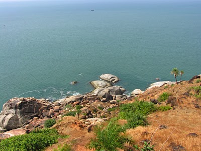
About 3 km from the town and near the jetty is the lighthouse, reached via a winding path that passes through shrubs and vegetation. Perched on a hill, it’s set on a small plateau. It offers a spectacular view: the sea below you, stretching far into the horizon; the jetty and its boats; the palm-fringed coastline to the left; and a creek far away trailing out to the sea. To the right is a sheer drop down to the sea past jagged cliffs. To the north-west are the Vengurla Rocks, also called Burnt Islands, which was an important pointer for seafarers in times long gone.
 |
| VIEW FROM THE LIGHTHOUSE |
It’s well worth strolling around the lighthouse. The northern tip overlooks an alluring horseshoe-shaped beach. Small winding pathways lead down to small coves, which are in reality tiny strips of sand with the cliff-face rising on both sides.
Vengurla Jetty Once a bustling port, Vengurla’s jetty is a part of settlement set up by the Dutch. The best time to visit the jetty is in the evening when the boats return with the day’s catch.
Date Established : 1869
Latitude: 15° 51 Min. 12 Sec.
Longitude: 73° 37 Min. 0 Sec.
Name : Vengurla Light
Location : Southern Maharashtra, southwest coast of India Arabian Sea.
Nearest Town or City: Vengurla, Sawantwadi, Malwan
Managing Organization: Department of Lighthouses and Lightship Central Government
Tower Height: 43
Height of Focal Plane: 269
Characteristic and Range: Red flash every 5 seconds, range 24 nautical miles.
Description of Tower: Hexagonal masonry tower with black and white bands ; lantern dome is red. Attached to dwelling.


No comments:
Post a Comment
Note: Only a member of this blog may post a comment.